Arctic Permafrost Atlas offers insights into the North’s changing landscape
A new atlas exploring everything about permafrost has been published this month, something those behind the project hope will give readers a fresh understanding on the changes occuring in the Arctic.
“It’s really hard to picture what permafrost is when you only see it online,” Hugues Lantuit, a permafrost expert and the atlas project coordinator, said in a phone interview.
“While we can immediately see the impacts of climate change on sea ice or glaciers, permafrost presents a much greater challenge, despite its extensive effects on various components of the Earth’s system.”
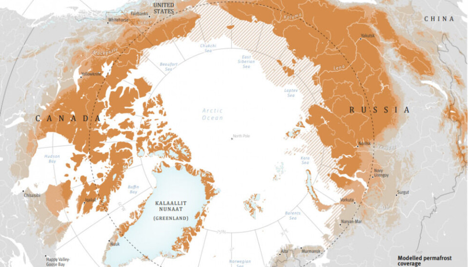
The effects encompass carbon storage, coastal erosion, and their implications for people living on permafrost in the circumpolar North.
“It’s quite challenging to convey all of this in a single place or setting where all these components can be addressed holistically,” Lantuit said. “That’s precisely what we aimed to accomplish with this project.”
Importance of Arctic voices
The Arctic Permafrost Atlas includes 176 pages featuring maps, illustrations, and photographs, as well as unexpected elements such as artwork and testimonials from individuals residing and working on Arctic permafrost.
Lantuit, who also heads the Permafrost Coasts working group at the Alfred Wegener Institute, Helmholtz Centre for Polar and Marine Research (AWI) in Potsdam, Germany, also has extensive field experience in Canada’s western Arctic and said bringing local voices and artwork into the atlas is one of the important things that sets it apart.
“We know very well that [as scientists] we are very gifted at making things complicated,” he said. “And we wanted to show that permafrost can be approached in very different ways.”
The atlas came out of the Horizon 2020 Nunataryuk project, a European-funded initiative led by the Alfred Wegener Institute in Germany. The project brought together social scientists, physical scientists, economists, Arctic residents, and engineers, among others, to examine permafrost changes in the North.
Nunataryuk means between land and sea in Inuvialuktun, an Inuit language spoken in northern Canada.
Information exchange
In all, Nunataryuk involved more than 150 scientists from 14 countries doing everything from on-site permafrost research with local communities, to computer simulations to socio-economic analyses.
The atlas showcases the results of the project.
“One of the strengths of our project is that we don’t focus on one country,” Lantuit said. “You get the sense of the information exchange across the polar communities that gets us out of that unidimensional axis between the South and the North.
“Looking at this exchange of information across the North is very important and is what this atlas seeks to promote.”
The atlas is currently available as a free PDF download.
Plans are also in the works to make printed versions available.


