
The newly discovered island is 410 x 200 meters with the highest point 27 meters above sea level.
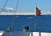
With melting glaciers appears new islands, this year at Novaya Zemlya
While low-laying islands in the Pacific Ocean disappear under rising seas, geographers have to redraw Arctic maps as land previously hidden underneath ice-covered waters pops up.

August 21, 2020
ADVERTISEMENT
The new island was first seen by Russian schoolchildren studying satellite images of the remote Arctic archipelago of Novaya Zemlya.
This week, a detachment of the military Northern Fleet sailing with representatives of Russia’s Geographical Society along the west coast of the northern island could confirm what the school children could see on computer screens.
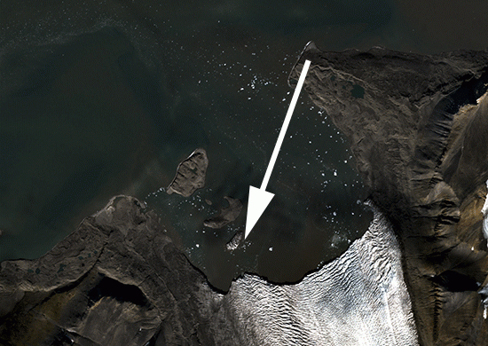
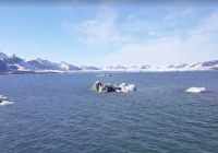
A larger part of the southern arm of the glacier stretching out in Vilkitsky Bay has collapsed and melted, and a new island has appeared. The island is 410 by 200 meters and its highest point is 27 meters above sea level. The name of the archipelago dividing the Barents Sea and the Kara Sea has literally spoken again proved truth. Novaya Zemlya is Russian for New Land.
The official confirmation of the new island is dated July 9, 2000, based on satellite images from the bay, according to the Northern Fleet’s press service who was first to publish the photo.
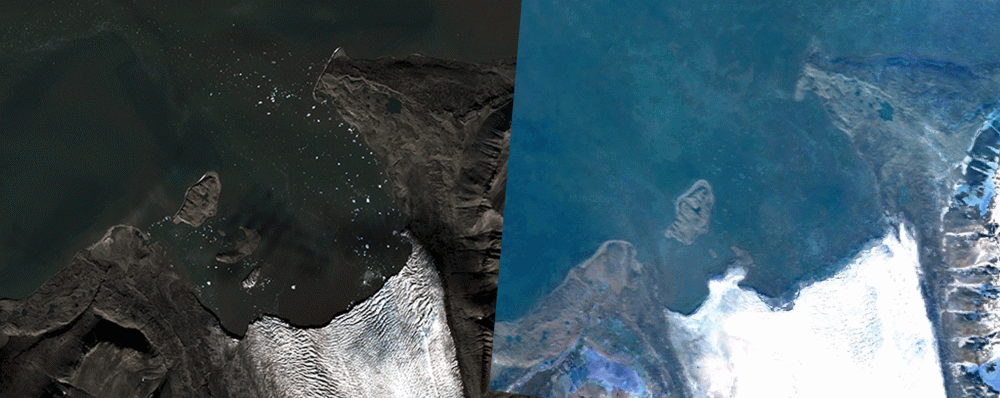
The speed of the melting glacier in the bay is best understood when comparing a Google Earth image from only a few years back with the satellite image of this summer. The edge of the glacier has retreated somewhere between 800 and 1,000 meters since the Google Earth image was taken.
Three other islands in the bay were discovered in recent years. The 2018 islands discoveries in the Vilkitsky Bay were also first made by Russian schoolchildren studying images from the three satellites KANOPUS-V, Landsat-7/8 and the Sentinel-1/2, the state corporation for space activities (Roscosmos) reported.
ADVERTISEMENT
Last year, The Barents Observer reported about the discovery of five new islands in the the Russian Arctic, of which the largest was a 54,500 square meter big located in the area of the Nansen glacier on the east coast of the northern island of Novaya Zemlya.
In the period 2015-2018, there were found more than 30 other new islands, bays and straits in the Russian Arctic where glaciers are melting in record speed amid global warming.
While new islands are coming to the Arctic because of climate changes, the opposite happens in the southern hemisphere. At least eight low-lying islands in the Pacific Ocean have disappeared under rising seas and destroying waves cased by the same climate change, New Scientist reported referring to a study in Micronesia and the Solomon Islands.
Nuclear bomb tests
Melting glaciers is not only causing map-drawers to reshape Arctic maps. Some glaciers in the Russian Arctic holds dangerous secrets. In 2018, a science expedition to Novaya Zemlya discovered big concentrations of radioactivity in the ice on the glaciers now melting into the sea.
From 1957 to 1962, a total of 86 nuclear bomb tests were carried out in the atmosphere at Novaya Zemlya. The tests include the largest nuclear devices ever exploded, like the so-called 58 megatons Tsar-bomb on October 30, 1961.
Most bombs were exploded above ground at the northern polygon near the Matotchin Shar dividing the northern and southern island of the archipelago. Wind direction, for the most, was towards the north when the tests took place.
It is the fallout from these tests that now are about to melt out to the sea.

ADVERTISEMENT
Sections
Arctic Read more
The Barents Observer Newsletter
After confirming you're a real person, you can write your email below and we include you to the subscription list.