ArcticInfo ‒ A digital service for safer seaborne voyages in the Arctic
ArcticInfo provides important information on sailing conditions in the Arctic, supporting decisions for safer navigation in Arctic waters. Map-based and accessible to all, ArcticInfo covers large areas off the coasts of Norway, Iceland, Russia, Canada, and Greenland, plus the Barents and North Seas.

By: Anders Røeggen // BarentsWatch and Anne Grethe Nilsen // Norwegian Coastal Administration
Low temperatures and extreme weather conditions, limited daylight over long periods of time, limited communication and infrastructure, poor charts, and large distances are some of the challenges that navigators face in Arctic waters. On top of this, there are almost always very limited resources nearby if accidents occur. To strengthen maritime safety and protect the environment, the Norwegian Coastal Administration has gathered voyage-related information in one place: ArcticInfo, available via BarentsWatch.
Users must register to get full access to the service, though much information is available without registration. Registered users can edit data about their own vessel, such as maximum speed, ice class, gross tonnage, rescue capacity, communication capabilities, helicopter deck, and a doctor/nurse onboard.
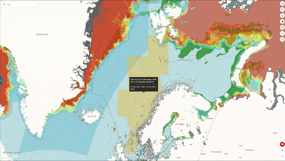
ArcticInfo provides information about icebergs around Greenland, icing, ice concentration from the Meteorological Institute in Denmark and Norway (drift ice and solid ice), storm warnings for Norway, Canada, Iceland, and Russia. Weather stations and ship information based on AIS (Automatic Identification System) from the Norwegian Coastal Administration are included.
“We want to offer a regularly improved service that can support navigators in making well deliberated and safe choices along the way,” explains Jon Leon Ervik, Head of the Department for Navigation Technology and Pilotage Management at the Norwegian Coastal Administration.
Maps showing the ice edge, wind, current and temperature, depth curves, quay conditions, and Norwegian maritime borders are included in the service. You will find an option to send your voyage plan digitally to the Greenlandic authorities.
A user-based service
Since its launch in early 2020, ArcticInfo’s user group has proven to be very diverse. A starting point for the service was the increasing cruise traffic prior to the Covid-19 pandemic, but fishing boats, the coast guard, and research and expedition vessels have used the information service.
Taitsianguaq Olsen is a marine pilot based in Nuuk, and co-owner of the company Imaq Pilot. In addition to pilot assignments, they offer services for mariners in relation to the Polar Code and a service for yachts and other larger recreational vessels.
“I use ArcticInfo to check vessel movements in the waters around Greenland,” says Olsen. “Depending on the time of year, I use the function ‘Ice concentration’ to see the ice edge in the map.”
Olsen hopes to use the service more when cruise ships can once again sail along the coast of Greenland, hopefully from next year.
Terje Solberg Johansen from the Joint Arctic Command in the Faroe Islands says they use ArcticInfo as a supplement to other navigation equipment onboard their vessels.
“We especially use it in connection with AIS to see which vessels operate in the Faroese fisheries zone 200 nautical miles from the baseline and to the border to Norwegian waters. But, most of all, we use the service to see Danish navigation warnings for our area.”
The Faroese Command is based in Mjørkadalur on Streymoy. It is the command authority of the Danish Armed Forces under the Danish Navy Operative Command. In addition to safeguarding the sovereignty of the Danish Commonwealth, they also carry out tasks such as fisheries inspection, search and rescue, medical transport, and other public service tasks.
The Arctic Monitoring and Assessment Programme (AMAP) is an international organisation that is now part of the Arctic Council, and aims to obtain information about the status of and threats to the Arctic environment.
“Together with many other partners, we carry out environmental assessments of the consequences of climate change in the Arctic Ocean. In this work, it is important for us to know how many and what types of vessels use the area,” explains Mario Acquarone at the AMAP Secretariat.
Will further develop the service
The Danish Maritime Authority was to develop ArcticInfo, but due to reorganisation and lack of funds, the Norwegian Coastal Administration was asked to take over the development and operation of the information service.
“As this task was a perfect fit with BarentsWatch’s mandate, we agreed on a collaboration where BarentsWatch would develop the new information service based on data from the Norwegian Coastal Administration.”
Once conditions allow people to meet safely, the Norwegian Coastal Administration plans to host a user conference.
“We want a dialogue on how we can further develop the service to meet the needs of our users. Today, we have basic information that contributes to navigation safety and environmental protection, but there is great potential for creating an even better user experience. In the long term, we envisage integrating information that can support tourism, fisheries, cruise traffic, and public administration.”
Today, users can add important information for authorities responsible for emergency preparedness and search and rescue services in Arctic areas. In the long term, the next step would be to add digital sailing routes for Svalbard, information about ice routes and icebergs, and whale observations.
“The service already includes Navigational Warnings and Notices to Mariners for Denmark, Greenland, and the Faroe Islands. We are now working to include similar information for Norwegian waters, and we hope to have this in place by the end of 2022. Our vision is a comprehensive and reliable information service where navigators can find important and useful information for safer voyages in the High North.”
This story is originally published on the website of the Fram Centre